Xochicalco sits abreast three hills in the Miacatlán region of Morelos, a little further south from Cuernavaca and the Toluca Valley. The area surrounding the hilltops show signs of human occupation from around 200BC, but it wasn’t until the Epiclassic Period, between 650AD-900AD, that the site was urbanised and the majority of the structures seen today were constructed. The delay between occupation and the formation of an urbanised civic centre may be due to the eruption of Mount Xitle which is broadly thought to have occurred sometime between 50AD-350AD. The volcano lies only 29 miles north of Xochicalco and decimated the surrounding areas, leaving the region inhospitable for a long time. The eruption drove a large number of people north to the city of Teotihuacan, which grew immensely to become the first megalopolis in the Americas and one of the largest cities the world had ever seen.
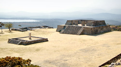
Building D and Plaza of the Stela
At some point in the 7th century, the sacred hill of Xochicalco was chosen to become a beacon of science, religion and commerce. No one is sure if the foundations for this purpose-built centre were laid by the Teotihuacano as they headed south, or by the Zapotecs as they headed north, by the Maya as they ventured west, or a mysterious group known as the Olmeca-Xicallanca who rose up in the area further east during the same period. Traits of all of these civilisations and cultures can be found within Xochicalco, which has led to the common theory that was a multi-cultural melting pot where goods and ideas and were exchanged between all of these cultures.
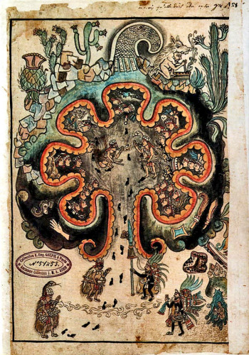
Diagram of ChicomoztocThe answer to who Xochicalco’s mysterious founders were may lie with the Olmeca-Xicallanca, who are one of the tribes recorded as heralding from the legendary birthplace of Mexican civilisation, the caves of Chicomoztoc. This legend may have its roots at Teotihuacan, which was named by Chicomoztoc’s most famous children, the Mexica/Aztec, and means “Birthplace of the God’s”. Thus far, five caves have been uncovered beneath its three main pyramids. This certainly raises the possibility that the legendary seven tribes of Chicomoztoc that populated Central Mexico and the area around Xochicalco were in fact groups fleeing the failing city of Teotihuacan during the 6th and 7th centuries. Xochicalco and Cacaxtla (home of the Olmeca-Xicallanca) both reached their apogees at the time of Teotihuacan’s terminal decline, which suggests these two cities either contributed to its downfall by competing for these essential resources (primarily cotton), or were the chosen destinations for the people of Teotihuacan as they abandoned their ageing, isolated and over-populated city.
At its zenith, Teotihuacan’s trading network stretched the length and breadth of Mesoamerica as they sought to maintain their burgeoning city through commerce. They are known to have subjugated the Zapotec city of Monte Alban in pursuit of cotton and influenced the expansion of the Mayan city of Tikal pursuit of jade, which included the founding of trade centres in Copan and Quirigua on the far-flung border of south-eastern Mesoamerica.
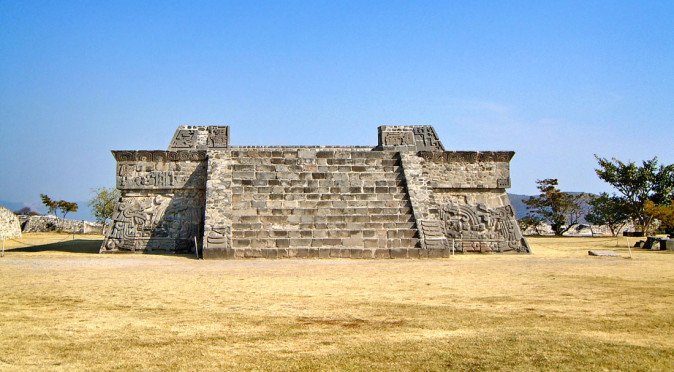
W0107: Xochicalco: Stela 3At Xochicalco there are clear examples of a Teotihuacano influence in both the architecture and its monuments. The most prominent examples are the three stelae that were found buried in the Temple of the Stelae. Stela 3 clearly features the Teotihuacano god Tlaloc, with the distinctive goggles (see fig. W0107), whilst the other two stelae feature a god known as Quetzalcoatl, the feathered serpent, who also has his roots at Teotihuacan. Stela 2 has a picture of Teotihuacan and is thought to describe how Quetzalcoatl created the fourth (or fifth) sun there. The plumed serpent is also boldly represented on the Pyramid of the Plumed Serpents, which was also built in an iconic Teotihuacano form of architecture known as the “talud-tablero” style.
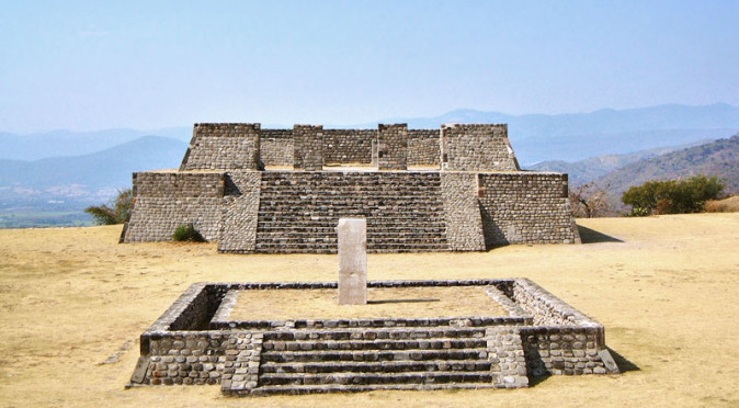
However, the superbly carved Pyramid of the Plumed Serpents also features a number of characters dressed in attire that is synonymous with the Maya and seated in a typically Mayan fashion (see fig. W0074). The three stelae that were excavated from the Temple of the Stelae are also in an artistic style more in keeping with the Maya and the fourth-sun, which appears depicted on Stela 2, was the Mayan age-of-man (the Central Mexican belief was that it was the fifth-sun). The Maya were also very keen on the porticoed temple design and this is found throughout Xochicalco.
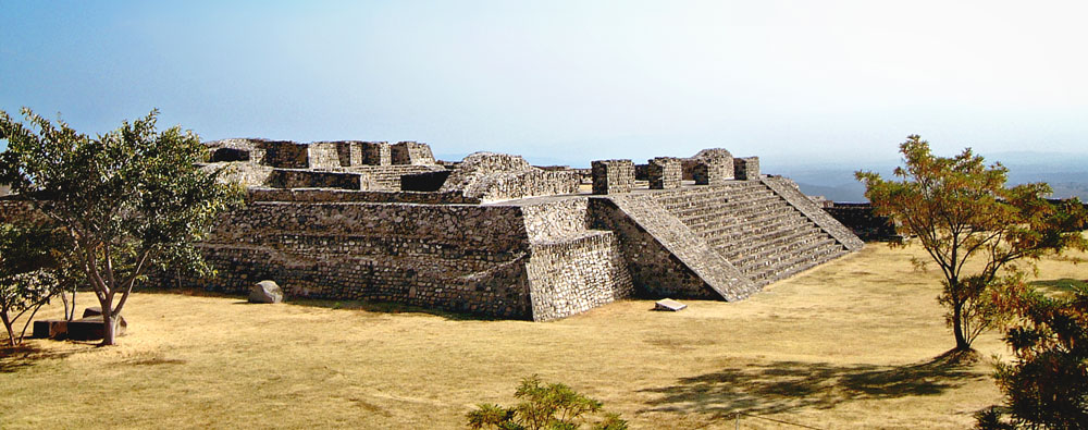
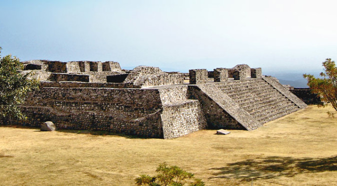
W0096: Pyramid of the Stelae
Elsewhere, influences from Monte Alban can be found, particularly in the Northern Ball-Court, with its distinctive high walls, and the Temple of the Stelae, which is built as a self-contained “System”, identical to those found at Monte Alban. Curiously, System M and System IV at Monte Alban feature a 15º north-of-west axis despite the rest of the hilltop city being built on a true north-south axis. Xochicalco also features these two different alignments, with the Temple of the Stelae facing 15º north-of-west and the southern complex, including the Plaza of the Two Glyphs, aligned on a true north-south east-west axis. Another feature that the two cities share is a zenith tube, with both the Observatory at Xochicalco and the Observatory at Monte Alban featuring a shaft that restricted direct sunlight from entering their chamber unless the sun moved directly overhead, which happened twice yearly. Intriguingly, this phenomenon correlates with the Sacred Calendar used throughout Mesoamerica, for the number of days between the sun moving directly overhead on its journey south and returning overhead on its journey north is exactly 260 days at Xochicalco. Teotihuacan’s Pyramid of the Sun was also designed to capture the zenith-event by facing the point on the horizon that the sun would set on zenith days – an alignment that was also approximately 15º north-of-west. 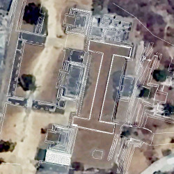
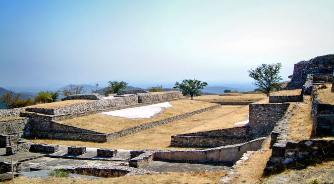
W0085: East Complex AlignmentRemarkably, the perpendicular alignment of the Pyramid of the Moon, 15º east-of-north, was also aligned with the rise of the pleiades which occurred within hours of the zenith sunset. At Teotihuacan, the entire city was laid out on this off-axis and Xochicalco all the buildings of the Central Plaza, the Northern Ballcourt and the East Complex replicate Teotihuacan and face the setting sun of the zenith-day at 15º north-of-west. Meanwhile, the Eastern Ballcourt follows the Avenue of the Dead and runs 15º east-of-north, to the point to the pleiades. As for Monte Alban, System IV and System M both feature the talud-tablero architectural style that is synonomous with Teotihuacan and were constructed between 450AD to 500AD when Teotihuacan held sway over the city.
It therefore appears that Xochicalco was fundamentally aligned with Teotihuacan, both physically, scientifically, and religiously – and so it would stand to reason that it was aligned politically too. The circumstantial evidence certainly adds up to suggest that a migrating group from Teotihuacan were indeed responsible for Xochicalco’s construction and it was through them that the Monte Alban and Mayan influences were introduced. The evidence also suggests that Xochicalco was purpose-built for celestial observation and not as citadel, built to defend against and control the neighbouring settlements.
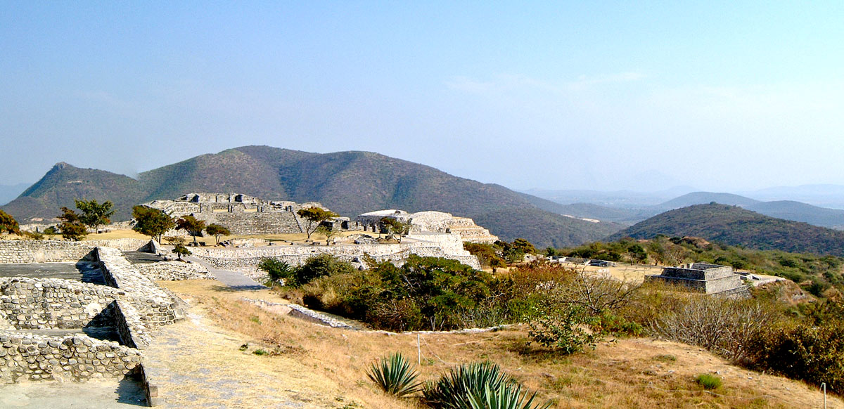
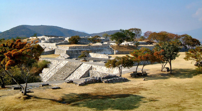
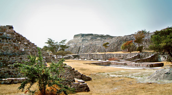
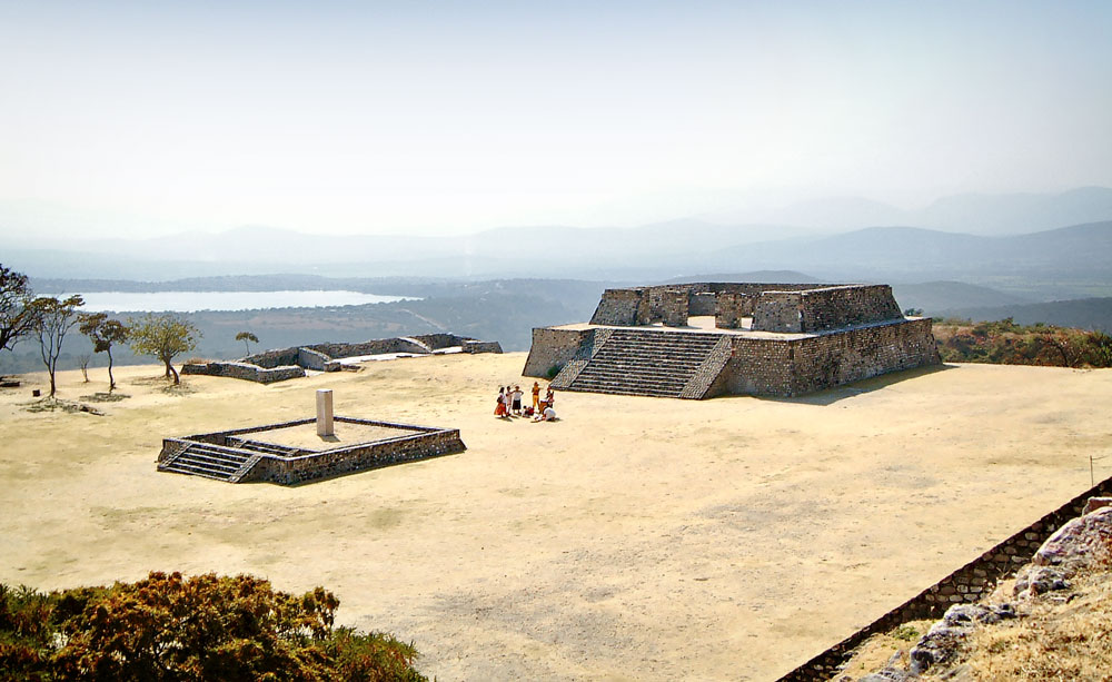
W0100: Xochicalco’s Structures framed by the Mountains
Hilltops were sacred places to the Mesoamerican’s and many cities were built in front of hills to venerate them. A perfect example is Teotihuacan’s Pyramid of the Moon, which was built to emulate and venerate the mighty Mount Gordo that dominates the background when viewed from the Avenue of the Dead. Amazingly, at Xochicalco the city’s structures also appear to have been built to replicate the hills that surround it (see fig W0100). Almost all Classic Period hilltop cities were built to serve a religious and scientific purpose – that of celestial observation (La Quemada, Teotenango, Monte Alban, etc.), and it was only during the decline of the 9th and 10th centuries that they were modified to act as fortresses. The area surrounding Xochicalco is particularly poor for agriculture and it would have been clear to its builders that it would not support a large population, so its position was almost certainly chosen for celestial and solar observation. Mesoamerican astronomers are known to have used distant hills as markers and buildings were placed accordingly. The incredible number of peaks and valleys on the craggy hills of the eastern horizon (see fig W0100) gave Xochicalco a unique ability to research and record celestial cycles and to develop and co-ordinate the two distinct Sacred and Solar calenders that were used throughout Mesoamerica. This central role in pan-Mesoamerican astrology and calendrics appears to be evident amongst the carvings of the Pyramid of the Plumed Serpents, which some researchers believe was built to host and commemorate a meeting between the “Lords of Time”, who came to Xochicalco to witness a key celestial event and to recalibrate the Sacred and Solar calendars.
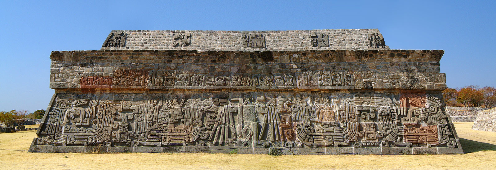
W0074: Pyramid of the Plumed Serpent featuring Mayan artistic principles and characters, including the “Lords of Time”
It wasn’t just Xochicalco’s ceremonial core that was centred around science and religion, but also its trade, which appears to have been manufacturing obsidian blades. Much of Teotihuacan’s dominance had been built around the trade in obsidian as they mined it in huge quantities. Obsidian played an important part in religious ceremonies, but was also essential for hunting and domestic use, and the key to building a powerful army. Through its role as a influential religious centre and growing rich through trade, Xochicalco rose to prominence and wielded huge political power within the surrounding districts. Unfortunately, it seems Xochicalco’s success brought about a population boom that it could not support. The surrounding valley was not equipped to feed its immense population, thought to peak at around 10,000-15,000, and when the Mesoamerican trade routes collapsed during the 10th century, along with the majority of the big cities, Xochicalco was doomed. This pan-Mesoamerican collapse thought to have been caused either by a period of long and destructive draughts or a volcanic eruption that left the skies darkened and caused crops to fail – there is evidence of both. But certainly Xochicalco shared its fate with many other Classic Period cities, and firstly the erected walls, ditches and other defensive features to keep its starving population out, before finally succumbing to the turmoil, at which point the city was ritually burned and then abandoned in around 900AD, after just 250 years of occupation.