Perched high upon a narrow hill 400m above the Oaxaca Valley floor, the spectacular city of Monte Alban was home to the Zapotec civilisation from around 500BC to 700AD. The city dominated the landscape and controlled the valley thanks to its strategic location at the heart of the Oaxaca valley. The historical consensus is that Monte Alban was built here by the nearby Zapotec population at San Jose Mogote to provide a dominant fortress city and seize control of the warring tribes of the valley. Although ultimately this was the result, the evidence suggests the city was built here for quite different motives.
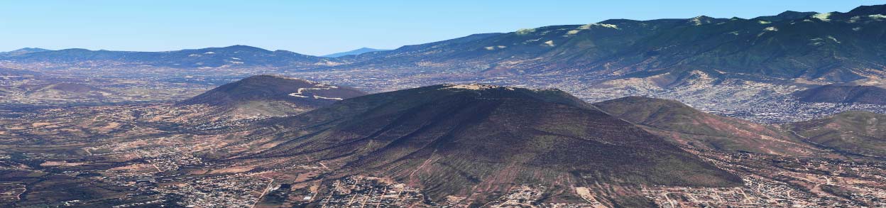
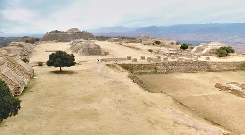
Fig. MAE01: The sandy stonework of Monte Alban is just about visible on top of the craggy hill, centre shot
The earliest signs of occupation at Monte Alban date from 500BC, but the monumental construction phases didn’t begin until 200 years later. Amongst the first buildings are the Observatory, System IV and System “M”, along with the artificial flattening of the Main Plaza, the Northern Platform and the Sunken Patio. This slow development of an intensely ceremonial space does not suggest there was any urgency or defensive requirement for the city – in fact, the city’s defensive walls were added several hundred years after the city had risen to power. Whilst San Jose Mogote was home to half the valley’s entire population and does appear to have been attacked, there is little other evidence to suggest that they built the city. The earliest buildings at Monte Alban were vastly more sophisticated than those found anywhere in the valley at the time, and the concept of artificially flattening a hilltop in order to build a large ceremonial centre is wildly out of kilter with the primitive societies and basic building techniques found throughout the valley during this period.
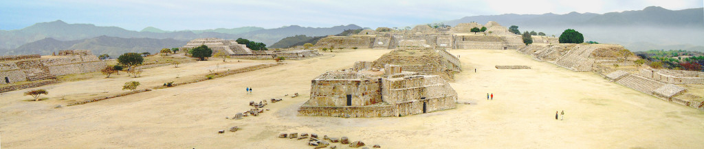
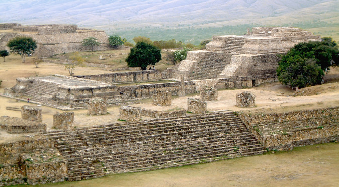
W0269 – Main Plaza Looking North, with the oddly shaped Building J, known as the observatory, directly in front of us
With sophisticated buildings such as Building J, System “IV” and System “M” being amongst the first buildings, there is certainly a suggestion that a more advanced civilisation from outside the valley may have influenced or even built the city – and there is an obvious contender. The Olmec, from the nearby coastline of Veracruz, were the foremost civilisation and elite force of Mesoamerica with a history spanning thousands of years at the time when Monte Alban was built. 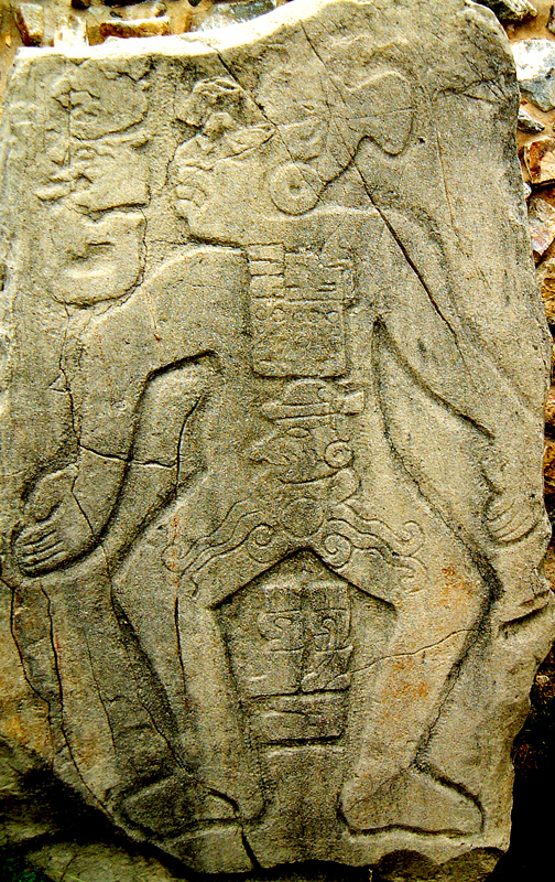
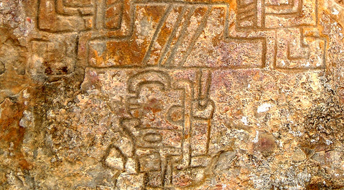
Fig W0276 – Olmec Danzante? They certainly had the technical ability and manpower to build Monte Alban – and 300 intriguing Olmec style images, known as Danzantes, certainly support the argument that they were responsible. The Danzantes are a series of iconic reliefs featuring strange, morbid, rubbery characters that appear to be diseased and deformed. Their message, and purpose, is a complete mystery and they are one of the many encrypted messages scattered around the city (see the article “Are the Danzantes Evidence of an Epidemic“). Trade between the Olmec and the people of San Jose Mogote is known to have been strong prior to the construction of Monte Alban, and it is thought they were keen to develop other cultures to extend their trade networks.
Of all the buildings at Monte Alban, it is Building J (seen above in Fig W0269) that immediately prompts the suggestion that there is more to Monte Alban than first meets the eye. It simply doesn’t fit, and although it was one of the first monumental buildings completed, its odd shape and juxtaposition to the rest of the Main Plaza and its temples cannot be put down to bad planning or poor architecture – in fact, if anything, it is an example of architectural and scientific mastery. Its odd pentagonal shape points, literally, like an arrow to the south-west and it is believed it was deliberately designed to align with the star Capella on its heliacal rising.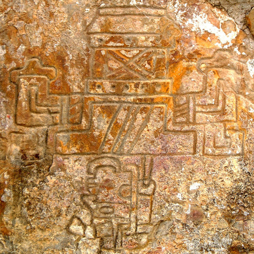
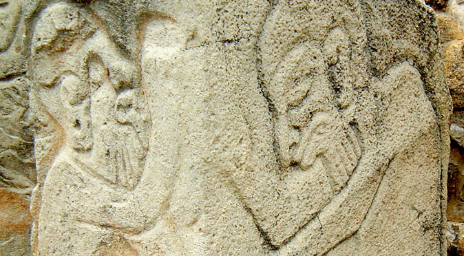
fig. 0258 – Conquest Slab It also has a Zenith Tube built into it which illuminated the temple floor when the sun passed directly overhead – which happened to be the same day Capella rose (see Monte Alban: The Ancient Observatory). This amazing feat of engineering and science again suggests Monte Alban was the work of an experienced and ancient civilisation. It also provides the first hint that astronomy may have been the real reason for building on the craggy impractical hilltop – for Monte Alban is one of the few cities in the world that enjoys incredible 360° views of the horizon. The encryption built into Building J doesn’t end here either, because mounted into its walls are around 40 curious reliefs featuring upside-down heads, most of which are engraved on large slabs and built into in the external wall of the Observatory. The reliefs are thought to be of captive tribal leaders slaughtered during the victorious conquests of the city, but it seems more likely that they represent those who were chosen to be sacrificed during the festivals that would have accompanied the celestial events that the Observatory was designed to capture (see “Monte Alban: The Conquest Slabs?” ).
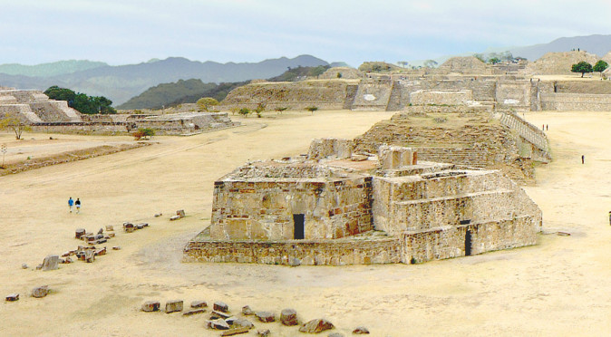
Hig W0245: Monte Alban’s Patio Hundido (Sunken Patio) and Main Plaza
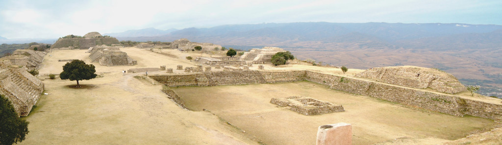
When it comes to engineering, Building J is just one example from a whole city of incredible feats. In fig. W0245, you can see the extent to which the hill had to be cut away and flattened by the builders to create the open spaces required for religious festivals and market trading. In fact, the work was even more dramatic than photo W0245 can detail, for we are actually looking down from the third tier to a second tier, in which a sunken patio has also been hacked further down into the rock, and incredibly beyond the upward stairs you can see leading out of the sunken patio is a row of broken pillars which are at the top of another set of stairs leading down 40 feet down to the third tier of the main plaza – this final set of stairs is visible in the distance of W0269 leading up to the sunken patio from the far end of the plaza. In fig. W0245 you can just about see a man standing on the far left corner of the sunken patio which helps put the colossal size of the Sunken Patio and the Main Plaza beyond him into perspective. The main plaza alone stretches for 300m from north to south and 200m from east to west.
The Sunken Patio (Patio Hundido) curiously dates from the earliest phase of construction and, as well as providing a formal area for events, the walled arena was scientifically designed to reflect sound and amplify it. This helped elevate the speaker’s voice above the noise of the crowd as well as producing a throbbing loudness to the drums and chanting of the audience – a phenomenon that is replicated in today’s carefully designed sports stadiums. Normally, these enclosures are produced by building walls and temples around the perimeter, but in this instance they elected dig down into the hilltop to carve the space out. As you can see from the one person stood at the corner in front of us, there would be plenty of room for tens of thousands of people to stand around the top and inside the theatre, making this a far bigger space than necessary.
Despite having a Temple/Patio arena sufficient to hold the entire population of the city, the Patio Hundido is replicated twice at Monte Alban with smaller scale versions known as System IV and System M. These two Systems are identical, although the complex at System IV was continually adapted resulting in a far more enclosed arena with higher walls and a grander temple. In fig. MAE02 you can see these “twins” in a satellite image of the main ceremonial centre at Monte Alban. To locate them, firstly identify the large square of the Patio Hundido which is easily visible to the north of the open expanse of the Main Plaza. You can then see its temple, known as Temple “B”, which is attached to the west wall. Below the Patio Hundido and to the left you will see a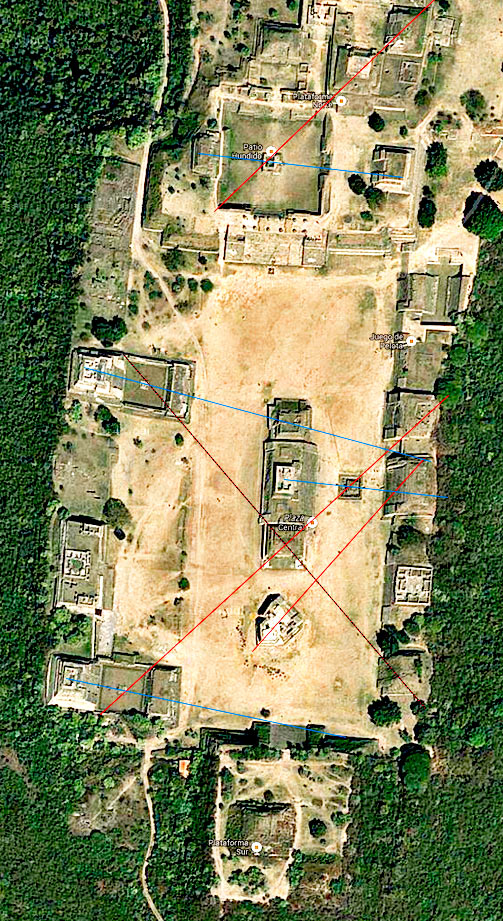
Fig. MAE02: Monte Alban Satellite Image smaller square which also has a temple attached to it; this is System IV. If you follow the left flank of the plaza further south, you will then see an identical temple group, known as System “M”. All three Temple/Patio groups are aligned slightly south of east and might be designed to target sunrise on specific days by tracing a path from the Temple through the square platforms which all three patios have located at their centre (in MAE02 they look like small white squares or dots). There is also a large platform in the Main Plaza to the right of the three central temples (it is so large it is easily confused as another temple in MAE02), and if you drew a line from the centre of the middle temple through the centre of this platform then you would find it also points slightly south of east. The angle of System IV is the greatest, and may have been aligned to point to sunrise on the winter solstice, which was a very important festival as it signified the end of one solar year and the beginning of the next.
The geometric encryption doesn’t end there, for if you cut a line diagonally through the patios of systems “M” and “IV” and their respective central platforms, then the lines meet exactly in the centre of Building “I”, which is the southernmost temple of the central trio – the red “X” quite literally marks the spot in fig. MAE02. And it isn’t just a crude “X”, it is comprised of four right-angles. The line from System “M” also goes on to cut through the centre of the platform in the Main Plaza and on to Building “II”. With System IV, the diagonal line goes on to dissect a building known as Monticulo Q (or Mound Q), the southernmost building of those that line the east side of the plaza. From the top of the Temple of System IV, a line through it central platform would bisect Building “G”, the northernmost temple of the three conjoined temples in the middle of the Main Plaza. There is also a line that cuts diagonally through the Patio Hundido and heads northeast cutting diagonally through Building “B” and then Building “VG” with unerring accuracy.
Whilst the lines alone could be dismissed as meaningless and the “X” as a coincidence, the numbers of proposed alignments add weight to the idea the city is encrypted with astrological information that would be easily deciphered by the High Priests of the city. Bizarrely, it is the least obvious alignment from the point of the oddly shaped Building J which leads perpendicular through the rear of the temple to a sighting hole on Building P which has been tested and proved as an astronomical alignment with a star named Capella – this opens the possibility that the entire city is encrypted with celestial events. There are also monoliths and Stelae, including Stela 18, that are known to be cosmically aligned and add credence to the idea that the whole city is an observatory or celestial timepiece. The accuracy in which the “X” is formed from 4 right-angled triangles to take the form of a flattened pyramid further supports the idea that these alignments are not a coincidence.
With all the evidence considered, it is clear that the builders of Monte Alban were incredibly sophisticated and not only had both the manpower and engineering capability to hack the hilltop into a monumental complex, but also had the scientific knowledge to carve it into a complex celestial clock. This herculean effort was clearly devoted to a scientific and religious endeavour and not to provide a safe haven from marauding tribes or to create a megalopolis designed to control the Oaxaca Valley. Being able to predict simple celestial events, such as the passing of comets, eclipses, helical risings, equinoxes and solstices, would have appeared magical when Monte Alban was built. It is entirely plausible that Monte Alban’s encryptions provided the High Priests’ with such profound knowledge of celestial activities that their predictions of celestial events and their influence on the weather, seasons, and even animal behaviors (including human patterns), would have appeared Godlike. As a result, Monte Alban may have allured the people of the valley and beyond to join the city entirely through mysticism and religion and swell the city population to as many as 20,000 people as has been estimated. The evidence certainly suggests the city was not intended to be a fortified capital designed to subjugate the valley, but rather a sacred sanctuary dedicated to reading the celestial objects of the skies.
There is one last piece of information that is has to be included. The Zapotec Civilisation believed themselves to be the “Cloud People” and that their ancestors descended from the skies. It is possible that the hill on which Monte Alban stands was the legendary spot that the builders believed their ancestors landed. It has been suggested this legend alludes to the visitation of extra-terrestrials and this is why the city was so advanced in comparison to other civic centres in the valley. Whilst this is dubious, though not dismissible, the celestial obsession built into the fabric of Monte Alban supports the idea that its builders believed their ancestors lived amongst the stars and communicated through celestial appearances and activities. Therefore, Monte Alban may have actually been built to communicate with the ancient ancestors – which is a common theme amongst the cities of Mesoamerica, but rarely on this scale.